

Houston is preparing for another turbulent weekend as meteorologists warn of two strong storm systems expected to sweep across the region. The first line of storms arrived early Saturday, rattling windows with thunder and high winds, while a second round looms later this evening with the potential to deliver heavy rainfall and localized flooding.
First Wave Hits Before Dawn
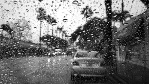
Residents across the Houston metro area woke to the sound of thunder between 3 a.m. and 6 a.m. as the first storm front barreled through the region. Rainfall totals ranged from half an inch to more than two inches in some neighborhoods. Strong gusts toppled small trees, disrupted early traffic, and left scattered power outages. By mid-morning, the skies cleared, allowing a brief window of calm that many hoped would last.
Brief Relief Before the Next Round
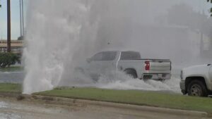
The break between systems offered a deceptive sense of normalcy. Warm, humid air returned by midday as the atmosphere recharged for another burst of energy. Meteorologists caution that the second system, forming west of the city, could pack more intense winds and prolonged downpours than the first. With the ground already saturated, drainage ditches and bayous are expected to rise quickly once the evening storms arrive.
Second Line Expected Tonight
Forecasters anticipate the next line of storms to reach the Houston area between 8 p.m. and midnight. While severe weather isn’t guaranteed, the risk for flash flooding, hail, and isolated tornadoes remains. This late-night timing raises additional safety concerns, as many residents may be on the road or attending evening events. Officials urge caution, reminding drivers to avoid flooded underpasses and never attempt to cross water-covered streets.
What Residents Should Do
-
Charge electronic devices and keep emergency supplies within reach in case of power outages.
-
Move vehicles to higher ground and secure outdoor items that could be blown by wind.
-
Stay indoors during the storms and monitor weather alerts throughout the evening.
-
If traveling, check local updates and consider adjusting plans to avoid the heaviest rainfall periods.
Looking Ahead: A Cooler, Clearer Week
Once both storm systems move through, Houston is expected to see a sharp drop in temperatures. A cool front will settle in by Sunday evening, bringing drier air and marking a noticeable shift toward fall. Highs in the 70s and lows in the 50s are expected for much of the coming week — a welcome change after weeks of humidity and intermittent rain.
The Bigger Picture
This latest weather pattern underscores the Gulf Coast’s vulnerability to rapidly developing storm systems, even outside hurricane season. Urban development and dense infrastructure continue to challenge Houston’s drainage capacity. City engineers are monitoring rainfall data closely to assess flood mitigation efforts and to identify where upgrades may be needed most.
FAQ
When will the second round of storms arrive?
Most models indicate the storms will reach the Houston metro area between 8 p.m. and midnight, tapering off by early Sunday.
How much rain could fall in total?
Two to four inches of rain are expected, with higher localized amounts in flood-prone zones.
Is there a tornado threat?
The risk remains low but possible, particularly within stronger cells embedded in the evening storm line.
What’s the forecast for next week?
After the weekend’s storms, expect cooler, drier weather with mostly clear skies through midweek.