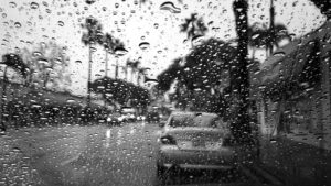


Houston is once again bracing for a weekend of turbulent weather as the National Weather Service places much of Southeast Texas under a Flood Watch through early Sunday morning. Meteorologists warn that back-to-back waves of storms could bring high winds, flash flooding, and widespread power outages.
Storm Timeline and Expected Impact
Saturday 3 a.m. – 5 a.m.
The first line of strong storms swept across the Houston metro area in the early morning hours, bringing wind gusts above 50 mph and knocking out power to more than 180,000 customers. Trees and power lines were downed across several neighborhoods, particularly north and west of the city.
Saturday 3 p.m. – 8 p.m.
A second round of scattered storms is expected by mid-afternoon. While not as widespread as the morning system, this wave could still produce heavy rainfall, localized street flooding, and isolated hail.
Sunday 2 a.m. – 6 a.m.
Meteorologists anticipate another band of strong storms overnight into Sunday morning, with renewed flooding risks in low-lying and urban areas. The region’s saturated soil and full bayous will make drainage slow, amplifying the chance of flash flooding.
Flooding and Power Concerns
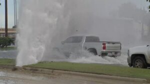
Officials warn residents not to drive through flooded streets, as even shallow water can stall vehicles or conceal hazards. With rainfall rates potentially topping two inches per hour, areas near the Buffalo Bayou, White Oak Bayou, and other smaller creeks are being closely monitored for overflow.
Power crews are on standby as wind gusts could again down lines and damage transformers. CenterPoint Energy crews have been working through the weekend to restore service following overnight outages.
What Comes Next
After the storms pass, a significant cool front will move in, bringing relief from humidity and ushering in autumn-like temperatures. Highs are expected to fall into the low 70s by midweek, with morning lows dipping into the 50s — and possibly the upper 40s by Friday. Halloween forecasts currently point to clear, cool, and dry conditions.
Safety Precautions for Residents
-
Avoid flooded roadways and underpasses.
-
Charge mobile devices and prepare flashlights in case of power loss.
-
Monitor local alerts and weather apps for real-time updates.
-
Check on elderly neighbors or those living in flood-prone zones.
-
Keep vehicles parked on higher ground away from drainage areas.
The Bigger Picture
Houston’s frequent flood events highlight ongoing challenges with stormwater management and infrastructure resilience. As extreme weather becomes more common, city planners and engineers continue exploring long-term solutions, from bayou expansion projects to enhanced retention systems.
FAQ
Which areas are under the flood watch?
Most of Southeast Texas, including Harris, Fort Bend, Montgomery, and Brazoria counties.
When will conditions improve?
Storms are expected to clear by late Sunday morning, with improving weather through the week.
Could tornadoes form?
While the tornado risk remains low, isolated spin-ups cannot be ruled out, especially in early morning storms.
How much rain is expected?
Total rainfall could reach four to six inches in some areas, with localized higher amounts.