
Houston has always lived on the edge of the elements. Floods, heat waves, fog thick enough to swallow freeways, and storms that spin out of nowhere are just part of the city’s personality. But this week felt different. This week felt tense. As a historic stretch of fall heat refused to break, forecasters began warning that a violent shift was coming, one that would snap the city from late-summer swelter into storm-driven chaos. Houstonians didn’t need televised alerts to sense it. The air felt wrong. The clouds hung heavier. Even the wildlife seemed restless.
What made this week so unsettling wasn’t just the forecast itself. It was the timing. Fall is supposed to give Houston a break. It’s the season when evenings get softer, when joggers reappear on trails, when lawns revive from sunburn and neighborhoods finally get to breathe after months of relentless humidity. Instead, the city remained locked in heat that bordered on oppressive. By the time Monday rolled around, even lifelong residents were admitting they’d never seen a November like this.
Meteorologists began sounding the alarm early in the week. A powerful storm system was forming west of Texas, gathering moisture and energy on its way toward the Gulf. As it strengthened, the system threatened to collide with an atmosphere already overloaded with heat. That mixture can be explosive. Not in the dramatic hurricane sense, but in the way that creates sudden downpours, spinning clouds, unpredictable lightning and pockets of damaging wind. It’s the kind of weather that catches cities off guard because it unfolds in hours, not days.
Residents reacted in the uniquely Houston way: part preparation, part denial, part gallows humor. Hardware stores saw a rush for batteries and tarps. Grocery stores noticed weekend-level crowds midweek. Social media filled with memes about “November acting like July” and jokes about the city’s weather having an identity crisis. But beneath the humor was something quieter. People were uneasy. They remembered the freeze of 2021. They remembered Harvey. They remembered the derechos, the tornadic bursts, the freak storms that turned neighborhoods into lakes in the time it takes to order takeout.
City officials weren’t laughing. Emergency managers increased staffing. Public works teams inspected storm drains known to clog. Crews trimmed trees near power lines. The city prepared as if this were a tropical event, even though the impending system wasn’t that. It was simply unpredictable. And unpredictability is what Houston hates most, because residents know that storms here don’t need a name to be destructive.
As the week progressed, the air grew thicker, almost electric. Even in the late evenings, temperatures hovered at levels that felt out of season. People walking their dogs noticed shorter tempers among the animals. Birds circled strangely, as if looking for escape routes. Outdoor workers said they could “smell something coming,” a phrase Texans use when storms are close but not yet visible.
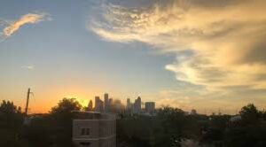
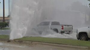
By Wednesday morning, the first signs appeared. Western counties saw the sky darken hours before predicted. Wind gusts began whipping through trees with little warning. A wall of clouds, towering and layered, advanced toward the metro area like a slow-moving tide. Houstonians paused at windows and on porches, watching the horizon collapse under the weight of the incoming system.
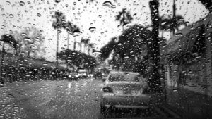
Then the storm arrived. Not all at once, but in alternating waves. The first burst brought sudden sheets of rain that pounded rooftops and sent steam rising from the pavement. The next brought violent flashes of lightning, the kind that linger in the sky and fork outward like tree roots. Streetlights flickered. Airplanes were rerouted. Some neighborhoods lost power for short spells as transformers overheated. Others, ironically, saw temporary relief from the heat as the rain-cooled air cut through the city’s trapped warmth.
But the storm’s real impact wasn’t measured in broken branches or brief outages. It was measured in the way the city breathed afterward. The temperature dropped sharply. The oppressive heat that had gripped the region for weeks evaporated almost instantly. By Thursday morning, Houstonians stepped outside to air that felt alive again. Crisp, cleaner, almost startling in its coolness.
People talked about the shift as though it were supernatural. “It felt like the sky had to break,” one Heights resident said. Another joked that the city had been “waiting for the weather to exhale.” Some simply looked relieved. Others looked annoyed, wondering how much this kind of instability would become the new normal.
Climate scientists have an answer for that, and it’s not comforting. As the Gulf warms, as seasonal patterns distort, as atmospheric moisture increases, transitional events like this become more violent. Heat lingers longer. Storms form faster. Temperature swings become more extreme. Houston is living in the earliest stages of that new climate reality.
Still, the city handled this week’s shift with the resilience that defines it. Neighbors checked on each other. Parents adjusted school schedules. Workers watched the radar with practiced eyes. Houstonians may complain about the weather, but they know how to navigate chaos better than most places.
What happened this week was not a disaster. It was a warning wrapped in a weather event, a reminder that Houston’s relationship with the sky is changing, tightening, becoming more unpredictable. The city survived the heat, braced for the storm, endured the shift and embraced the coolness that followed. But no one who lived through it will forget how strange the air felt in the days before the sky finally snapped.